Taking the Roads Less Traveled, with Spectacular Results
Ever since moving into our house in Salem almost nine years ago, the wilderness has beckoned to me. From our living room, kitchen nook and backyard, the Cascade Mountains call in the distance, with Mt. Jefferson punctuating our visible skyline.
But exploring the back country wasn’t much of an option before the past year. We didn’t feel comfortable taking our family station wagon “off-road” on the forest roads that crisscross much of the state’s wilderness. But last year, I finally traded in the trusty Volvo for a used Honda Element with all-wheel drive, and we finally felt confident that we could explore the wilderness by going where there were only narrow and windy gravel roads.
At the same time I got the Element, I invested in a DeLorme Oregon Atlas & Gazetteer, a detailed topographic map book that recorded all of the forest service dirt roads as well as labeled mountains and other recreation sites with more precision. With my training from my days in the Army National Guard, I could tell how steep the terrain was by how closely the lines showing elevation changes were spaced on the maps’ mountains and hills.
Armed with the gazetteer, we began exploring the forest service roads in the Willamette National Forest and Mount Jefferson Wilderness to get closer glimpses of our beloved Mt. Jefferson.
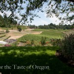
Today, on the last day of my second furlough this year, Charles and I decided to head for the Willamette National Forest again. We packed a picnic lunch to enjoy along the way. We headed east on Highway 22 from Salem and in about 40 minutes we were turning onto the roadway that spans the top of massive Big Cliff Dam, which forms Detroit Lake, and then headed onto National Forest Service Road 2212. At first the roadway was paved, winding its way along the edge of Detroit Lake. Between the Douglas Fir we could catch glimpses of the blue-green lake as we rose higher and higher through dense moss-laden trees and fern-clad cliffs.
After about five miles, we reached the very top of one mountain and were startled to find the mountainside bare from logging. The road hugging its shoulder looked precarious, like it could slip off the mountain at any moment. We were on top of Kinney Ridge. There were no guard rails. I pulled over and we looked behind us at the now-distant lake. Charles took out his iPhone and launched the altitude app. It registered 2,800 feet. We kept going another mile until we passed the logged-out area and re-entered dense forest. There the pavement stopped and turned to gravel.
The climb became steeper, the gravel road narrower and more windy. I kept my eye on the road while Charles looked at the vista. At around 3,000 feet we got our first glimpse of Mt. Jefferson through the tops of the trees and took a moment to snap some photos before heading higher. Even though it was in the 70s when we left Salem, the air was cool at this altitude and I donned my fleece jacket. We began noticing mounds of snow hugging the shaded cliff face of the mountain next to the dirt road.

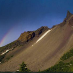
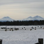
Mt. Jefferson glows in the distance.
At about 3,200 feet, we got a full glimpse of the lake, which seemed minuscule now, and Mt. Jefferson against the gray sky. Most of it was still covered in snow and it seemed to glow, calling to us from the distance. We stopped to take several photos before heading on about three more miles, when we were abruptly greeted by a roadway of solid snow. Charles, the voice of reason, said it was time to turn the car around and head back.
We parked by the clearing where we had a full view of Detroit Lake and Mt. Jefferson, and ate our picnic lunch. The only time we took our eyes off Mt. Jefferson was to pick at the chicken and potato salad in the Tupperware and make sure we didn’t spill it on ourselves.
Finishing our lunch, we decided we would try our luck on this road in a month to see if the snow had cleared, and discover what other vistas were awaiting. Then we slowly began our descent towards home.
— Vic
Category: Outdoors
About the Author (Author Profile)
Victor Panichkul is a journalist and writer by training; a cook, wine lover and photographer by passion; and a lover of the outdoors since moving to Oregon more than 10 years ago. He is a native of Bangkok, Thailand.
Subscribe
If you enjoyed this article, subscribe to receive more just like it.


What a wonderful trip. It reminds me of some of the trips Bill and I took shortly after retiring.
I have great memories of going up that road when I was young. My family camped at Detroit Lake every summer. My father would do some lake fishing, but preferred to fly fish. So we were always going off the main roads to logging roads, etc. trying to find the best new place to fish! He really liked that area. As kids we would find salamanders which were the highlight of the trip as far as I was concerned! Thanks for bringing back some of my favorite summer memories!
Time for a road trip!!!
Barby, thanks for commenting. Charles and I love exploring the forest roads to see what kind of vistas of the mountains we can catch. Which is your favorite?
Hi Marlene, I’m sorry that you and your husband aren’t able to travel and explore as much as you used to. I hope you come to visit us again before long.
Just make sure you fill the gas tank before leaving!